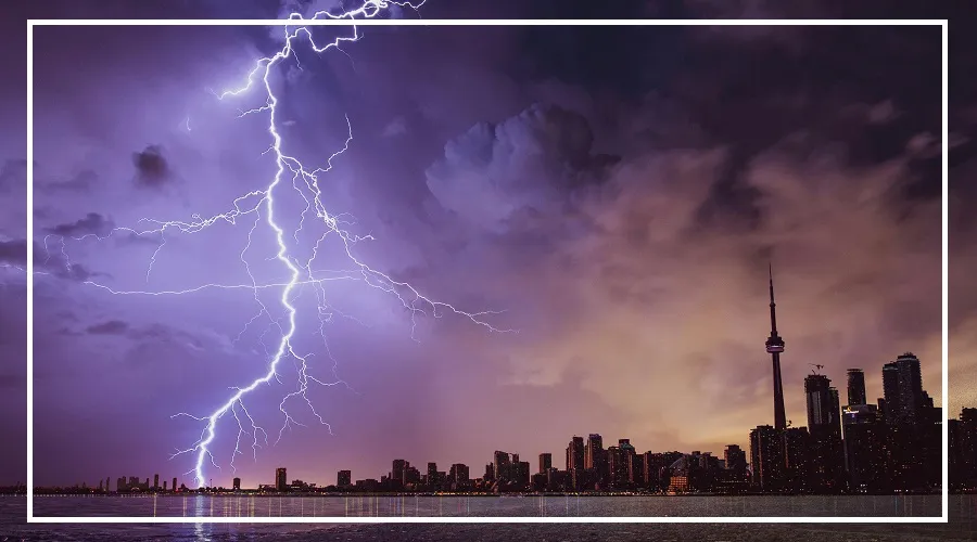
Residents of Delhi and the NCR got a welcome break from the heat on Monday (June 15) as light rain and strong thunderstorms brought cooler weather to several areas.
According to the India Meteorological Department (IMD), dense clouds moving from the Rohtak region triggered pre-monsoon rainfall across much of Delhi.
Due to the changing weather conditions, the IMD has issued Red and Orange alerts for thunderstorms and lightning in the national capital.
Strong winds of 60-70 kmph are expected, with gusts reaching up to 80 kmph in some areas.
However, this relief may be short-lived, as temperatures are likely to rise again by June 18, with maximum temperatures touching 40-42°C.

Monsoon Advances Rapidly Across India
The southwest monsoon is now moving faster and has expanded into several new regions of the country.
According to the IMD, the monsoon has covered more parts of Telangana, Odisha, Jharkhand, and Bihar.
It has also reached the remaining areas of Andhra Pradesh and West Bengal.
The Northern Limit of Monsoon (NLM) is currently passing through cities such as Hyderabad, Ranchi, and Muzaffarpur.
Weather experts believe conditions remain favorable for the monsoon to advance further over the next four to five days.
The IMD expects the monsoon to spread across the central Arabian Sea, Maharashtra, the remaining parts of Karnataka, Chhattisgarh, and more areas of Bihar in the coming days.
Heavy Rain Alert for Several States
The Meteorological Department has issued a warning for heavy to very heavy rainfall in parts of Northeast India and eastern India.
Sub-Himalayan West Bengal, Sikkim, Arunachal Pradesh, Assam, and Meghalaya are likely to receive heavy rainfall over the next six to seven days.
In the last 24 hours, Kokrajhar in Assam recorded 12 cm of rainfall.

Good rainfall activity was also reported from parts of coastal Karnataka, Odisha, and Bihar.
Rain Expected in North India Too
The weather department has predicted rainfall in Jammu & Kashmir, Ladakh, Himachal Pradesh, and Uttarakhand between June 15 and June 21.
Jammu and Kashmir could witness widespread rainfall from June 18 to June 21.
Punjab, Haryana, Chandigarh, Delhi, and Uttar Pradesh are also expected to receive rain accompanied by thunderstorms and lightning on different days during this period.
For Delhi specifically, the IMD has forecast dust storms, thunderstorms, and light rain on June 15 and 16.
Bihar Likely to Receive Heavy Rain on These Dates
Eastern and central India are expected to see increased rainfall activity this week.
According to the IMD, Bihar, Jharkhand, and Odisha are likely to receive scattered to moderate rainfall from June 15 to June 21.
Bihar could experience heavy rainfall on June 16 and again on June 19.
Rainfall is also expected across Chhattisgarh, Madhya Pradesh, and the Vidarbha region throughout the week.
Meanwhile, Kerala and Mahe are likely to receive heavy rain from June 15 to June 21, while coastal Karnataka may witness heavy showers from June 17 to June 21.
Tamil Nadu and Puducherry are expected to receive significant rainfall between June 16 and June 18.
Konkan, Goa, and Maharashtra are also likely to see regular rainfall during the week.
Dust Storms, Strong Winds and Heatwave Warning
While many regions are preparing for rain, some parts of the country may still face extreme weather conditions.
The IMD has warned of strong winds ranging from 60 to 100 kmph along with dust storms in parts of Rajasthan, Telangana, and Uttar Pradesh.
At the same time, heatwave conditions may continue in Telangana and Vidarbha for the next two to three days.
During the last 24 hours, Rajasthan’s Phalodi recorded the country’s highest temperature at 42.8°C, highlighting that intense summer heat has not completely disappeared despite the advancing monsoon.